Climate change is a geospatial problem
To change at the global level, we must understand the local level - but due to poor data, this problem is not easily solved. However, breakthroughs in geospatial analysis are unlocking new ways for capital markets, corporates and cities to transform complex global climate science into meaningful data to assess, price and mitigate climate-related risks.
The paradox of scale
At the macro-level, we are well aware of the task at hand - human activity is causing global imbalances to the earth’s subsystems. We must slow the rise of global temperatures, CO2 emissions must fall, and financial institutions and corporations must find ways to get to ‘Net Zero’ as soon as possible.
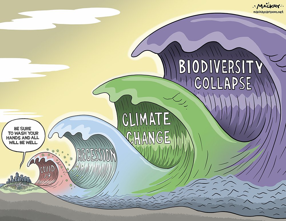
But despite these global goals, the impact of climate change is painfully local. In North America alone, wildfires are causing loss of life, property and businesses in northern California; the rising sea-levels (and inequality) in Miami; Hurricane Laura causing $20B in damages across the Caribbean and eastern United States.
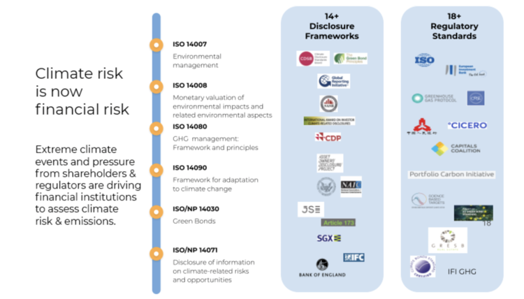
The paradox of scale is also seen in the current shift towards climate disclosures. Initiatives like the Task Force for Climate-related Disclosures (TCFD) and Network for Greening the Financial System (NGFS) are a crucial step towards greening the financial system. But these non-mandatory frameworks are yet to provide methodological rigor for assessing climate related risks. In many ways these initiatives are focused on top-level analysis and strategic level reporting. This prevents a deeper integration of climate-related data into operational purposes, due to the regulatory box-ticking exercise which is all to easy for banks, insurers and large corporates to fall into.
We all understand that climate change is a global problem, but we struggle to predict, price and manage the real world damage it causes. To fix this disconnect, we need better climate data. Current data is low-resolution, inconsistent and hard to use, and it requires complex data transformations to turn global climate models into signals for real world action.
But the times they are a'changin'.
Come gather 'round people, wherever you roam
And admit that the waters
around you have grown
And accept it that soon
you'll be drenched to the bone.
If your time to you
is worth savin'
Then you better start swimmin'
Or you'll sink like a stone
For the times they are a-changin'.
- Bob Dylan

Geospatial revolution
To transform science into a real world signal, multiple layers of data collection, aggregation and transformation must occur, with the end goal of providing granular, meaningful and transparent insights on how the climate affects our world. The following technology trends now make this type of analysis possible:
High-quality, high-frequency earth observation data for monitoring the globe has historically been expensive and hard to analyze, with most demand coming from government and military analysts. This scenario has been changing over the past five years — smaller, smarter and cheaper satellites are being launched in greater numbers, greatly expanding access to data.
Advances in artificial intelligence and computational capabilities have led to software-based, cloud-enabled platform start-ups which process petabytes of imagery data to deliver business insights.
Cloud-native processing and spatio-temporal analytics are key technical capabilities that enable this evolution.
Collectively, these themes fall under the category of ‘geospatial analytics’. This revolutionary set of new analytical capabilities can unlock significant opportunities for corporates and financial institutions as they seek more granular, transparent and meaningful climate data for mitigation and adaptation.
So what?
Over the past year, we have seen a concerted effort from the business world to “build back better” as we consider what’s next after the COVID crisis. This is a great first step, and has led to ambitious Net Zero targets set by global corporates, and the widespread adoption of non-mandatory climate risk disclosure frameworks (such as the TCFD, NGFS, SASB, and many others).
But, if we want to make measurable and meaningful progress in understanding how our changing climate will affect financial industry and corporate practices, we need to go beyond the minimum. Understanding the effects of climate change at the asset-level detail is key, as is the ability to analyze historical, present and future climate events.
Asset-level data will unlock meaningful change in financial sector practices, turning climate from a non-financial risk into an endogenous factor in every financial decision-making process. For example, more accurate climate data supports credit and lending functions at banks, who can reduce risk premiums and improve profit margins. These climate-resilient loans can then be bundled into new green structural products for capital markets, providing additional layers of profit. But to deliver these gains, banks require granular, transparent and meaningful financial indicators on climate.
This is where climate intelligence comes in. Through data transformations climate intelligence makes the massive amounts of geospatial data intelligible. This intelligence takes disparate data sets in a variety of resolutions, temporalities, and locations etc and transforms them into an easy to read graphical interface.
Want to learn more? Fill out the form below and we'll be in touch shortly!
[hubspot portal="25054470" id="11324217-5628-4ca5-bfaf-af5bff2894c8" type="form"]